

The application of mathematics to the Carolina Bays is only possible because well-preserved Carolina Bays have a mathematically elliptical geometry from which many characteristics about the bays can be deduced.
The modern story of the Carolina Bays started when commercial aviation gave us a new perspective of the Earth's surface. In 1930, some peculiar elliptical depressions near Conway, South Carolina were photographed by the Fairchild Aerial Surveys and they were brought to the attention of Professors Melton and Schriever from the University of Oklahoma.
In 1933, Melton and Schriever wondered whether the Carolina Bays could be meteorite scars. They noted that the bays have a smoothly elliptical shape, parallel alignment, a rim of soil at the southeastern end, and the bays can overlap while maintaining their elliptical shape. These authors concluded that the origin of the bays is not directly attributable to ordinary geologic processes and that the origin of the Carolina Bays from meteorite impacts was the most reasonable explanation.
Melton and Schriever defined a formula for ellipticity based on the width and length of the bays. This was one of the first applications of mathematics to the Carolina Bays. From the geometry of the bays, the authors concluded that meteors striking plastic material at angles between 35 and 55 degrees from the vertical would produce indentations elliptical in outline. However, further exploration of the Carolina Bays did not find any meteorite fragments or evidence of meteorite impacts.
In 1942, Douglas Johnson, a professor of geology at Columbia University, wrote a book about the origin of the Carolina Bays. Johnson refused to consider the elliptical geometry of the bays, and throughout his book, he referred to the bays as having an oval form. On page 325 of his book, Johnson claims that the images selected for publication are specifically chosen for their excellent regularity, and that this gives a completely erroneous idea of the type of bays that are most frequently encountered. Johnson proposed that the Carolina Bays formed by a combination of wind and wave action on lakes formed by artesian springs.
In 1977, Raymond Kaczorowski conducted an experiment to test the hypothesis that the Carolina Bays were oriented lakes like those found in Alaska. He carved a circular indentation on a sand tray that he filled with water to represent a model lake. He set a fan to blow over the water, and he changed the fan to blow in opposite directions every fifteen minutes for four hours. The experiment produced a pointy structure that was not elliptical. Kaczorowski's report was never subjected to peer-review, but it has been frequently cited by proponents of the wind and wave mechanism, also called the eolian-lacustrine hypothesis.
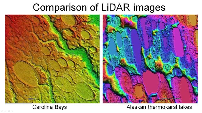
When LiDAR images became available, they revealed significant differences between the Carolina Bays and the thermokarst lakes in Alaska. Thermokarst lakes are created when permafrost melts and produces sinkholes that fill with water. The Carolina Bays have smooth elliptical shapes with raised rims, whereas the thermokarst lakes have rough irregular borders and do not have the overlaps that are present in many Carolina Bays. Considering the substantial geological differences, the Carolina Bays and the thermokarst lakes could not have formed by the same physical mechanisms.
In 2006, the book titled The Cycle of Cosmic Catastrophes, by Richard Firestone, Allen West, and Simon Warwick-Smith proposed that the Carolina Bays were craters made by pieces of glacier ice ejected by the impact of a comet into the ice of Hudson Bay. The book illustrates the convergence of the bay alignments in Wisconsin, which adjusted for the rotation of the Earth places an impact site by Lake Michigan. The next year, Firestone, West and 24 more coauthors published a peer-reviewed paper that introduced the Younger Dryas Impact Hypothesis, but it did not include the impact origin of the Carolina Bays.
In 2010, Davias and Gilbride found that the Carolina Bays and the Nebraska Basins had a convergence point in Wisconsin, similar to what had been described by Firestone. Davias and Gilbride examined geological depressions at the latitude of the convergence point and proposed Saginaw Bay in Michigan as the most likely point for the cosmic impact.
During his study of the Carolina Bays, Michael Davias developed a LiDAR visualization tool for Google Earth. The topography is represented by a 10-meter cyclic color ramp that provides the relative elevation of the local terrain.
Michael Davias also developed the Ovoid Basin Survey, which is a database of thousands of Carolina Bays containing characteristics for each bay, such as geographical coordinates, size, eccentricity and orientation.
The LiDAR images overcome many of the problems of aerial or satellite images that show a patchwork of farm fields and vegetation that obscure the geological features. The bays in the LiDAR images can be fitted with ellipses to show that the Carolina Bays are mathematically elliptical and not just oval. Ellipses are conic sections and the inclination angle of a cone can be calculated from the width-to-length ratio of the ellipse. This corresponds to the angle of impact.
In 2017, I published the Glacier Ice Impact Hypothesis in the peer-reviewed journal Geomorphology. The title of the paper is: A model for the geomorphology of the Carolina Bays. The hypothesis proposes that an extraterrestrial impact on the Laurentide Ice Sheet ejected pieces of glacier ice in ballistic trajectories, and the secondary impacts of the ice boulders liquefied the ground and created inclined conical cavities that transformed into shallow elliptical basins after viscous relaxation. The paper included pictures of some experimental impacts that illustrated the impact mechanisms.
The azimuths calculated from fitting ellipses to the Carolina Bays and Nebraska basins provide an objective method of determining the orientation of the basins. Using the distance of a Carolina Bay from the convergence point and the launch angle, it is possible to use ballistic equations to get estimates of the launch velocity of the ice projectiles. We can get useful values even if the exact launch point is not known.
Using ballistic equations for distances from 1,000 to 1,470 kilometers and launch angles from 35 to 45 degrees, we calculate that the launch speeds range from about 3 to 4 km/sec. The flight times vary from about 6 to 9 minutes and the maximum heights of the trajectories vary from 150 to 368 kilometers above the surface of the Earth. These calculations indicate that all the Carolina Bays and the Nebraska Basins would have been created within 6 to 9 minutes after the extraterrestrial impact on the Laurentide Ice Sheet.
The size of the ice projectiles can be calculated using yield equations that correlate impact energy to crater size. The program by Professor Jay Melosh and Ross Beyer from the University of Arizona calculates that a Carolina Bay with a diameter of one kilometer could have been made by an ice projectile with a diameter of 180 meters impacting at 3 km/sec at an angle of 45 degrees. The ice projectile would be about the size of Yankee Stadium, and the energy of the impact would be equivalent to about 3 megatons of TNT, which is 200 times more powerful than the bomb dropped on Hiroshima.
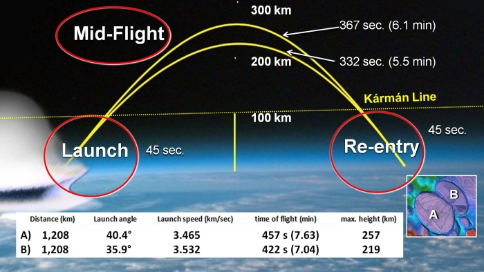
There are three stages of the ice boulder trajectories: Launch, mid-flight and re-entry. The ice projectiles interact with the atmosphere during launch and re-entry. The mid-flight of the ballistic trajectory is a suborbital space flight in the vacuum of space with no atmospheric friction. At such low pressure, water can only exist as a solid or a gas. Any liquid water ejected above the atmosphere quickly cools by evaporation and transforms into solid ice. Typical trajectories last from 5 to 6 minutes in mid-flight before starting re-entry through the atmosphere. Re-entry lasts approximately 45 seconds. An ice projectile encounters increasing air density as it traverses the atmosphere and its mass decreases due to ablation.
Using NASA's Ames vertical gun, Professor Peter Schultz from Brown University has demonstrated many times that a hypervelocity impact on an ice sheet sends a shock wave that fractures the ice and the expansion of a vapor plume launches ice chunks of various sizes in ballistic trajectories. These experiments provide support for the idea that an extraterrestrial impact on the Laurentide Ice Sheet could have ejected pieces of ice in ballistic trajectories to create the Carolina Bays.
A paper by Shuvalov and Dypvik describes extraterrestrial impacts by projectiles of various sizes. For a projectile with a diameter of 1000 meters, the mass of ejecta is so large that it moves the atmosphere itself to high altitudes. Thus, the atmosphere cannot decelerate even the fine ejecta and they consequently expand to the rarefied upper atmosphere. This means that the ice boulders that were ejected by the impact on the Laurentide Ice sheet were able to start their ballistic trajectories without significant ablation or melting from atmospheric friction because the ice boulders were lifted along with the atmosphere due to the large size of the impact.
During re-entry, the maximum dynamic pressure encountered by a projectile, called Max-Q, is one half of the air density multiplied by the square of the velocity. Calculating Max Q for speeds of 3.5 and 4.0 kilometers per second, we can see that the aerodynamic forces are smaller than the compressive strength of glacier ice, which can be 15 megapascals. This means that the ice boulders could have survived re-entry through the atmosphere without breaking up. Some weak ice boulders with a compressive strength of 3 megapascals could have fragmented at an altitude of 5 kilometers above the surface during re-entry, but at a speed of 3.5 kilometers per second, the pieces would have hit the ground 1.4 seconds after the fragmentation.
Ice projectiles re-entering the atmosphere at 3 to 4 kilometers per second and at an angle of 35 degrees would have spent from 43 to 58 seconds traversing the atmosphere. In 2019, I conducted an experiment to determine how much ice would melt during one minute at the re-entry temperature typical of the space shuttle, which is slightly lower than the 1,995 degrees Celsius produced by a propane torch. Blasting an ice chunk for one minute with a propane torch only melted 10 percent of the ice. This amount of ablation would have left enough ice to impact the earth and create the Carolina Bays.
We can be sure that the secondary impacts that formed the Carolina Bays were made by solid ice and not slush balls, watery snow, or any kind of slurry. Below the triple point of water, which is at 6 thousands of an atmosphere, water can only exist as a solid or a gas. Any liquid water that was ejected by the extraterrestrial impact or by piggybacking on an ice chunk quickly turned into ice crystals. Any wet ice boulders would have left a trail of ice crystals along their trajectories in the vacuum of space.
The Glacier Ice Impact Hypothesis uses the laws of physics as the mathematical foundation for calculating the characteristics of the impact basins and the extraterrestrial impact. The conic sections representing the Carolina Bays and the convergence point by the Great Lakes provide the initial conditions for the physics-based model. The ballistic equations provide the velocities of the ice projectiles. Yield laws correlating impact energy with crater size can be used to calculate the size of the projectiles. These calculations provide information about the extraterrestrial impact.
Ellipses are conic sections and this implies that the Carolina Bays and the Nebraska basins originated as inclined conical cavities or penetration funnels. The impact of a projectile displaces material and forms uplifted rims around the cavity. Experimental oblique impacts by ice projectiles produce inclined conical cavities that look elliptical when viewed from above.
In 2022, I coded a Python program to fit ellipses to the Carolina Bays by the least squares method. Points are selected along the perimeter of a Carolina Bay and the coordinates of the perimeter are processed by the program to graph an ellipse and calculate the azimuth of the bay. This program is open-source software available for everyone.
The Python program can process points from Google Earth geographical coordinates or from a digitized image. Geographical coordinates are converted to meters taking into consideration that the distance between degrees of longitude changes depending on the latitude.
The Carolina Bays are elliptical, and ellipses are conic sections, so where do the cones come from? The cones come from the shock waves.
A projectile moving through a viscous medium creates a conical shock wave as long as the frictional forces do not exceed the yield strength of the projectile. The shock wave dissipates quickly in a medium of low viscosity, such as air or water. An elastic medium, like ballistic gel, reverts to its original form, and retains the tubular path of the projectile, but not the conical shape. A viscous, non-elastic medium, like modeling clay, retains the shape of the conical shock wave, although the shape may change slowly under the influence of gravity.
The wind and water hypothesis and the thermokarst hypothesis cannot explain the mechanism by which elliptical overlapping Carolina Bays are created, but this is the natural result of adjacent impacts. This image illustrates different stages of adjacent experimental impact cavities undergoing viscous relaxation to produce overlapping basins.
Determining the dimensions of Carolina Bays that overlap is very difficult, but fitting ellipses to the bays by the least squares method provides an objective way of determining the width and length of bays that are partially obscured.
Using Google Earth, we select points along the perimeter of a bay, but we avoid the portion that is deformed by the overlap. The sample points are at the margin where the colorized topography indicates a change in elevation.
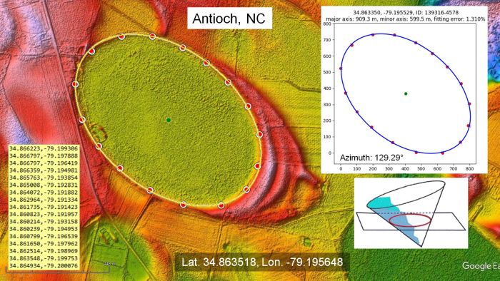
The Python program provides the width and the length of the ellipse. The width-to-length ratio of basin A is 0.648, which corresponds to an impact angle of 40.4 degrees.
We follow the same procedure of selecting points along the perimeter of basin B. Only five points are needed to fit an ellipse, but we have many more.
The ellipse fits very well through the points. The ellipse-fitting program makes it possible to determine the width of this basin. The width-to-length ratio of basin B corresponds to an impact angle of 35.9 degrees.
The impact angles obtained from the width-to-length ratios, and the distance of the bays from the convergence point are used to calculate the characteristics of the trajectories. The ballistic equations indicate that the glacier ice boulder that made basin A had a flight time of 7.63 minutes and reached a height of 257 kilometers above the surface of the Earth. The projectile that made Basin B had a flight time of 422 seconds or 7.04 minutes. From the law of superposition, we know that basin B was emplaced first, and from the ballistic equations we know that basin A overlaid basin B 35 seconds later.
The glacier ice projectiles that made these basins measured approximately one fifth of the basin length. The impact that made basin A had kinetic energy equivalent to 15.3 megatons of TNT, and the impact that made basin B had energy equivalent to 9.9 megatons of TNT. Both of these impacts produced seismic vibrations exceeding magnitude 8, which is more than enough to liquefy unconsolidated ground.
I calculated the energy of the impacts that made a cluster of Carolina Bays in a four-square kilometer area near Bennettsville, South Carolina.
Assuming an impact velocity of 3.3 km/s, which is about 9 times the speed of sound, and projectile diameters of one fifth the length of the bays, the energy of formation of these Carolina Bays was about 8 megatons of TNT per square kilometer.
In 2024, I modified the ellipse-fitting program to calculate the goodness of fit. The Pythagorean Theorem allows us to calculate the error distance, which is the distance between the point that we plotted and the path of the ellipse.
Standard measures of fitness, like the Mean Squared Error do not provide meaningful comparisons for ellipses of different sizes. The error measure needs to be independent of the number of sample points and the size of the ellipse. We calculate the sum of all the error distances between the observed points and points on the ellipse and divide by the number of points to get the average error. Then, we calculate the fitting error as the percentage of the average error relative to the semiminor axis of the ellipse, which is half the width of the ellipse. This process scales the average error to the size of the ellipse to allow comparisons of the errors for ellipses of different sizes.
Fitting the bays with ellipses by the least squares method is an objective way of determining their geometry. The mathematically elliptical geometry of the Carolina Bays is a clue that the bays originated as inclined conical cavities or penetration funnels. The Carolina Bays did not originate from thermokarst and they were not created by wind and water mechanisms. Based on the geometry, they are impact structures.
Well-preserved Carolina Bays, like those near Bowmore, North Carolina, have a mathematically elliptical geometry with an average fitting error of 1.59 percent. In general, Carolina Bays have fitting errors of less than 3 percent.
The image from Kaczorowski's 1977 thesis, where he claimed that the model lake changed from circular to elliptical, was digitized using WebPlotDigitizer. Fitting the points along the resultant shape with an ellipse produces a fitting error of 4.645 percent, which is much higher than the fitting errors for the Carolina Bays.
Not all Carolina Bays have a smooth and level central basin. This LiDAR image shows a large Carolina Bay 3.6 kilometers southwest of Chester, Virginia with a highly eroded center. The stony ground in Virginia did not allow the formation of penetration funnels like those that were made in the saturated, unconsolidated soil of North Carolina or South Carolina where the ground was liquefied by the seismic vibrations of the impacts.
The Carolina Bays in the rocky soil of Virginia were made by ice boulders that disintegrated on impact and plowed gravel and stony debris out of the way to leave the elliptical features that we see today. The mechanism is similar to the elliptical spatter patterns studied in forensic science.
Although this terrain is highly eroded, the rim has some well-defined portions, and it is possible to fit the points with an ellipse by the least squares method. This Carolina Bay has a major axis of 2682 meters, which is about 1.7 miles.
Unlike the the Carolina Bays in Virginia that are on rocky terrain, the bays in North Carolina are flat enough to be farmed. Notice that the bay in North Carolina has eolian sand sheets, which are evidence of the strong winds that accompanied the formation of the Carolina Bays. In spite of the substantial geological differences of the terrains in Virginia and North Carolina, it is significant that all these bays have a mathematically elliptical geometry. The hypothesis that wind and water mechanisms created the Carolina Bays cannot explain how these precise elliptical features were made on the hilly and rocky terrain of Virginia.
The application of mathematics to the Carolina Bays makes it possible to design a physics-based model for the extraterrestrial impact on the Laurentide Ice Sheet. We can add the energy for creating all the bays, and use the law of conservation of energy to estimate the energy and size of the extraterrestrial impact. The mathematical model provides a minute-by-minute account of the extraterrestrial impact and of the secondary impacts that made the bays.
In 2022, the LiDAR visualization tool for Google Earth made it possible for Eric Brown to find what appears to be a Native American solar observatory on the grounds of the Oxley Nature Center in Tulsa, Oklahoma. This elliptical basin, which may be a Carolina Bay, is oriented toward the Great Lakes. The rim has been neatly sculpted and the adjacent terrain has been modified with tangential lines that align with the equinoxes and solstices. The Tulsa Basin should be of interest to many archaeologists.
Many of the topics in this presentation are covered in my book The Neglected Carolina Bays - Ubiquitous Geological Evidence of a Cataclysm, which is available from Amazon.
